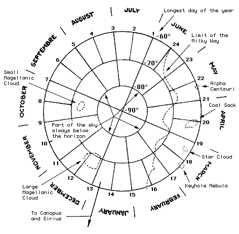
(Fig. 3) Modern day map of the region of sky below the -60° latitude.
| PREVIOUS PAGE |
I have divided a circular map of the southern region of sky below the
-60° latitude into 24 parts with number 1 starting between June and
July and numbering counter clockwise until we reach number 24. On this map
I have placed the location of the objects referred to above. With this calendar-map
combination we can detect what non stellar objects will be in the sky in
any given month of the year, or if we see the objects in the sky first,
we can tell exactly what season or month it is.
FLASH
TO FIGURE 4, STONE MAP
(Fig. 3) Modern day map of the region of sky below
the -60° latitude.
Now we will examine the stone, which looks like a spider web with some
imperfections. If we count the radiating lines at their ends we find that
there are 24 of them, but one of these lines is not connected to the main
network of lines. This is line number 1 on fig. 3. If we count counter clockwise
like on our modern map, (fig. 3), line 8 intersects with an oval shaped
line. On our modern map the line 8 intersects with the Small Magellanic
Cloud. If we count on, we find that line 12 points to another oval shaped
area, on our modern map line 12 intersects with the Large Magellanic Cloud.
Between lines 19 and 20 of the stone (fig. 4) we find a small raised area,
this corresponds to the Coal Sack located on fig. 3. Between lines 19 and
18 is another faint carving raised area, this corresponds to the star cloud
between lines 18 and 19 on fig. 3.
FLASH
TO FIGURE 3, MODERN MAP
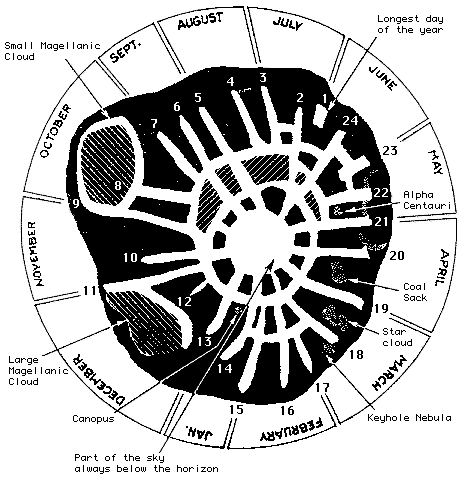
(Fig. 4) Ancient map of the region of sky below the
-60° latitude.
I believe that line 1 that is not connected to the other line system
indicates the longest day of the year (summer solstice), because it coincides
perfectly with the locations of the Magellanic Clouds. The circle in the
center indicates the unknown part of the sky below the horizon to those
who view the southern sky form +10° north of the equator. The closed
areas between line 21 of the stone and ending on the line 9 could indicate
cloud cover see fig. 4.
 (Fig.
5) The green area in the center indicates the part of sky not visible
to the observer +10° north of the equator. Go
to (Fig. 1) and notice that the area of sky is only visible down to
-80° latitude.
(Fig.
5) The green area in the center indicates the part of sky not visible
to the observer +10° north of the equator. Go
to (Fig. 1) and notice that the area of sky is only visible down to
-80° latitude.
The earth's axis does not remain exactly fixed in space but describes a
cone with an apex angel of 47 degrees. Instead of being an annual cycle,
however, it takes 25,800 years to complete. If we take this procession into
account we find that the stone loses accuracy and gets progressively worse
as we go back in time. It still works today but as time goes on it will
cease to be accurate. I feel that the stone was created roughly 500 years
ago.
The following diagram is average rainfall in Costa Rica during the period
1979-61. Information taken from: Atlas Estadístico de Costa Rica
Nº 2 - 1981. Notice that rainfall is greatest between November
and May.
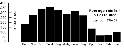
(Fig. 6) Rainfall 1979-61
Pay attention now! this is interesting. Below is the
stone with a crescent shaped area indicating what if feel is an indian
circular bar chart.
 (Fig. 7)
Green area indicates cloud cover over the mountains.
(Fig. 7)
Green area indicates cloud cover over the mountains.
I used a filter on a graphic arts program to convert the above image (fig.
7) from the polar to rectangular coordinate system.
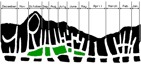
(Fig. 8) The stone displayed with the rectangular
coordinate system showing cloud cover over the southern mountains during
May to October.
Compare figure 8 and figure 6 and you will begin to see similarities between
the two. Rainfall and cloud buildup go hand-in-hand. The clouds build up
during the rainy season obscuring the sky behind them. I think whoever made
the stone was showing the observer the months and area of sky that were
likely to be obscured.
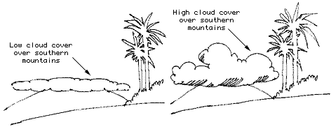
(Fig. 9) How cloud cover builds up during the rainy
season obscuring the sky behind them.
Conclusions:
I do not claim to be a scientist or archaeologist and I am sure that my
methods do no follow the proper guidelines of these disciplines. I feel
that someone with the training, time, experience and interest in this matter
should take the ball and prove or disprove this theory. After all, if I
am wrong and nothing is done, nothing is lost, but if I am right and nothing
is done... this priceless gift from the past could end up as land fill.
Bibliography
Una interesante hipótesis astronómica. La Nación, San Jose, March 25, 1979:7. (Supplement Ancora)
Mystery Stone Challenges Experts. The Tico Times, San Jose,
May 11, 1979:1,12-13.
Parques Nacionales de Costa Rica. p. 67.
| HOME PAGE Costa Rica In-focus
| TOP OF PAGE | PREVIOUS
PAGE |
CONCEPTOS DIGITALES C.R., S.A.
PUBLICIDAD EN INTERNET
All contents copyright © 1999, Conceptos
Digitales C.R., S.A. All rights reserved.
URL: http://www.zurqui.holowww.com/crinfocus/info.html Revised: May 13,
2004